NB: HIGH CONFIDENCE ON THIS FORECAST TRACK!!
UPDATE 1/TROPICAL DEPRESSION (unclassified) | DATE: 08 JUNE 2023 | DAY: THURSDAY | TIME: 02:30PM BST (+6 GMT)
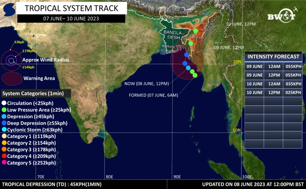
As of Thursday noon BST, the “Low Pressure Area” has intensified Into a Tropical Depression over East Central Bay of Bengal adjoining North East Bay of Bengal.
Multispectral satellite animation is showing notable rotations with deep convection sheared to the west of the mostly obscured Low Level Circulation Center.
It is being located approximately 240km South of Cox’s Bazar, Bangladesh.
.
★MAX WIND(1MIN AVG):-
Average Maximum Wind speed in radius of 50km from the low level center at 12pm Today is 45km/h. Gusting up to 60km/h.
.
★DYNAMIC ANALYSIS:-
Upper Level analysis indicates that the system is currently in marginally favorable environment due to Moderate VWS(15-20kt), Fair outflow, favourable SST (30°C), good lower level vorticity, moisture supply, and few relevant atmospheric parameters. This condition is likely to prevail over the next 2 days.
.
•Due to the aforementioned conditions, It could intensify gradually into a Deep Depression during next 12hrs & Maintain intensity during subsequent 12hrs. Then, It is likely make landfall Over Cox’s Bazar coast and weaken gradually even rapidly due to rugged terrain.
.
•With the above atmospheric condition, the System is likely to peak near 55kph(~1min) with gusting up to 70kph.
.
★MOVEMENT:-
It has moved in a North Northwest direction during the past 6 hrs with the average speed of 13 km/h.
*From the present location, it could move NW towards And recurve into north-east direction towards Cox’s Bazar coast. Post 9th June, the System could weaken rapidly due to land interaction over Southern Chittagong division.
.
★LANDFALL:-
It could cross Cox’s Bazar coast near Maheshkhali as a Deep Depression by Tomorrow Noon/Afternoon (9th June) .
.
★WARNING:–
Cox’s Bazar coast and neighboring Myanmar coast could experience 45-55 kph winds with gusts up to 70 kph by 9th June 2023 . Then, winds could reduce gradually.
.
★ADVISORY:-
Fishermen & Small boats are requested to not venture into the East Central and Northeast Bay of Bengal & neighborhood areas during next 24/36 hours. Currently, whoever is into the sea should stay close to the coast or avoid the risky area as stated here.
.
★RAINFALL:-
Due to the direct influence of the System, Chittagong division and neighboring Myanmar coast could have moderate to Very Heavy rain along with Tropical Squalls between 8-10 June 2023. While Barisal division could have the share of this rainfall.
.
★NOTE: This information is subject to change slightly. So, check new updates for better information!
Resources used in this analysis: Global Models, Himawari 9 Satellite, ER, 200hPa VP, 850hpa Vorticity, 500hPa Vorticity, Sea Surface Temperature, MJO, Synoptic Chart, Wind Shear, Subtropical Ridge.=>
Share as much as possible to inform everyone.
Stay connected for the next update!
Thanks, ©Bangladesh Weather Observation Team (BWOT).
*BENGALI:
দ্রষ্টব্য: এই পূর্বাভাস ট্র্যাকের উপর উচ্চ আত্মবিশ্বাস!!
আপডেট 1/ নিম্নচাপ (অশ্রেণীবদ্ধ) | তারিখ: 08 জুন 2023 | দিন: বৃহস্পতিবার | সময়: 02:30PM BST (+6 GMT)
.
বৃহস্পতিবার দুপুর পর্যন্ত, “লঘুচাপটি” উত্তর-পূর্ব বঙ্গোপসাগর সংলগ্ন পূর্ব মধ্য বঙ্গোপসাগরে একটি ক্রান্তীয় নিম্নচাপে পরিণত হয়েছে।
মাল্টিস্পেকট্রাল স্যাটেলাইট অ্যানিমেশন বেশিরভাগ অস্পষ্ট নিম্ন স্তরের সঞ্চালন কেন্দ্রের পশ্চিমে গভীর পরিচলন সহ উল্লেখযোগ্য ঘূর্ণন দেখাচ্ছে।
এটি বাংলাদেশের কক্সবাজার থেকে প্রায় 240 কিলোমিটার দক্ষিণে অবস্থান করছে।
.
★সর্বোচ্চ বাতাস (১ মিনিট স্থিতি):-
নিম্ন স্তর কেন্দ্র থেকে 50 কিমি ব্যাসার্ধে গড় সর্বোচ্চ বাতাসের গতিবেগ আজ দুপুর 12 টায় 45 কিমি/ঘন্টা যা দমকা হাওয়া সহ 60কিমি/ঘন্টা পর্যন্ত বৃদ্ধি পাচ্ছে।
.
★ডাইনামিক এনালাইসিস:-
উচ্চ স্তরের বিশ্লেষণ ইঙ্গিত করে যে সিস্টেমটি বর্তমানে মাঝারি VWS(15-20kt), মটামুটি বহিঃপ্রবাহ, অনুকূল SST (30°C), ভাল নিম্ন স্তরের ঘূর্ণি, আর্দ্রতা সরবরাহ এবং কয়েকটি প্রাসঙ্গিক বায়ুমণ্ডলীয় পরামিতির কারণে কিছুটা অনুকূল পরিবেশে রয়েছে। আগামী ২ দিন এই অবস্থা বিরাজ করতে পারে।
.
• উপরে উল্লিখিত অবস্থার কারণে, এটি পরবর্তী 12 ঘন্টার মধ্যে ধীরে ধীরে গভীর নিম্নচাপে পরিণত হতে পারে এবং পরবর্তী 12 ঘন্টার মধ্যে তীব্রতা বজায় রাখতে পারে। তারপর, এটি কক্সবাজার উপকূলে স্থলভাগে আছড়ে পড়তে পারে এবং রুক্ষ ভূখণ্ডের কারণে ধীরে ধীরে এমনকি দ্রুত দুর্বল হয়ে পড়তে পারে।
.
•উপরের উল্লেখিত বায়ুমণ্ডলীয় অবস্থা অনুযায়ী, সিস্টেমট সর্বোচ্চ 55kph(~1min) গতিবেগ পেতে পারে, যা দমকা সহ ৭০ কিমি/ঘন্টা পর্যন্ত যাওয়ার সম্ভাবনা রয়েছে৷
.
★গতিপথ:-
এটি গত 6 ঘন্টায় 13 কিমি/ঘন্টা গড় গতিতে উত্তর উত্তর-পশ্চিম দিকে গ্রসর হয়েছে।
*বর্তমান অবস্থান থেকে, এটি প্রথমে উত্তর পশিম ও তারপর উত্তর-পূর্ব দিকে অগ্রসর হতে পারে এবং কক্সবাজার উপকূলের দিকে অগ্রসর হতে পারে এবং সেখানেই আঘাত করতে পারে। এটি 9ই জুন এর পরে, দক্ষিণ চট্টগ্রাম বিভাগের উপর স্থলভাগের বাধার কারণে দ্রুত দুর্বল হতে পারে।
.
★আঘাত:-
এটি আগামীকাল দুপুর/বিকাল (9 জুন) নাগাদ গভীর নিম্নচাপ হিসেবে মহেশখালীর কাছে কক্সবাজার উপকূল অতিক্রম করতে পারে।
.
★ সতর্কতা:-
কক্সবাজার উপকূল এবং নিকটবর্তী মায়ানমার উপকূলে ৯ই জুন ২০২৩ এর মধ্যে ৪৫-৭০ কিলোমিটার বেগে দমকা/ঝোড়ো হাওয়া বয়ে যেতে পারে। তারপর, বাতাস ধীরে ধীরে কমতে পারে।
.
★পরামর্শ:-
মৎস্যজীবী এবং ছোট নৌকাগুলিকে আগামী 24/36 ঘন্টার মধ্যে পূর্ব মধ্য এবং উত্তর-পূর্ব বঙ্গোপসাগর এবং আশেপাশের এলাকায় না যাওয়ার জন্য অনুরোধ করা হচ্ছে। বর্তমানে, যারাই সাগরে আছেন তাদের উপকূলের কাছাকাছি থাকা উচিত বা এখানে বলা ঝুঁকিপূর্ণ এলাকা এড়িয়ে চলা উচিত।
.
★বৃষ্টি:-
সিস্টেমের প্রত্যক্ষ প্রভাবের কারণে, চট্টগ্রাম বিভাগ এবং নিকটবর্তী মায়ানমার উপকূলে 8-10 জুন 2023 এর মধ্যে দমকা বা ঝড় হাওয়া সহ সহ মাঝারি থেকে অতিভারী বৃষ্টি/বর্ষন হতে পারে। যদিও বরিশাল বিভাগেও এই বৃষ্টিপাতের অংশ থাকতে পারে।
.
★নোট: এই তথ্য সামান্য পরিবর্তন হতে পারে। সুতরাং, ভাল তথ্যের জন্য নতুন আপডেট চেক করুন!
এই বিশ্লেষণে ব্যবহৃত উপাদান: গ্লোবাল মডেল, হিমাওয়ারী 9 স্যাটেলাইট, ER, 200hPa VP, 850hpa Vorticity, 500hPa ভোর্টিসিটি, সমুদ্র পৃষ্ঠের তাপমাত্রা, MJO, সিনপটিক চার্ট, উইন্ড শিয়ার, সাবট্রপিকাল রিজ।
=>
যতটা সম্ভব শেয়ার করে সবাইকে জানিয়ে দিন।
পরবর্তী আপডেটের জন্য সংযুক্ত থাকুন!
ধন্যবাদ, ©Bangladesh Weather Observation Team (BWOT)।
Advertisements