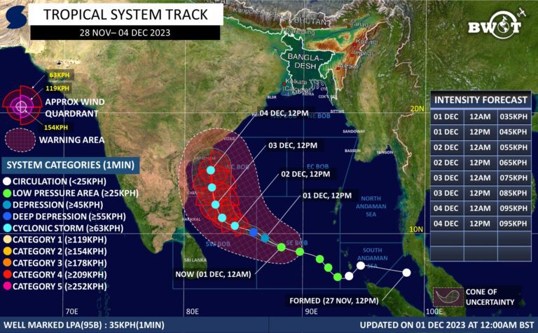
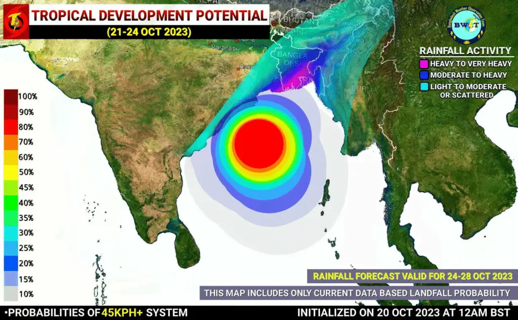
SPECIAL WEATHER UPDATE | DATE: 20 OCT 2023 | TIME: 6:30AM BST (+6 GMT) | SUB: TROPICAL DEVELOPMENT POTENTIAL | PERIOD: 21-24TH OCT 2023
Under the influence of a Disturbance (INVEST 92B), A Low Pressure Area could form over central parts of the Bay of Bengal within the next 24hrs.
BWOT’s dynamic analysis suggests that the potential system could intensify into a Well Marked LPA by 22nd October, and further intensify into a Depression / Deep Depression by 23-25th October. According to global models, there is a small window is open for further intensification of this system up to a minimal cyclonic storm. But BWOT doesn’t support any significant intensification with the given parameters below.
▪️Global Models suggest a Low Pressure Area development over central parts of BOB by 21st October. And possible intensification up to a Deep Depression between 23-25th October over West Central/NW Central Bay of Bengal & cross coasts across southern Bangladesh around 25th October. While some models also suggest intensification up to a minimal cyclonic storm by 24-25th Oct 2023.
◾ DYNAMIC ANALYSIS:-
According to dynamic analysis by BWOT, a poorly structured disturbance is trying to develop some convection over southern central Bay of Bengal. Sea Surface Temperature in the suspect region (central to northernmost BOB) is hovering around 29-30°C. That reflects a favorable water body.
Madden Julian Oscillation(MJO-RMM) signal is located over phase 1 with amplitude more than 1. Global model forecast suggests that MJO signal is likely to remain between phase 8-1 during the whole forecast period. So, it will not support the BOB system instead, the descending branch of MJO could cause less favourable atmosphere. And MJO filtered 200hPA Velocity Potential(-ve) Anomaly is passing through Africa and its convergence area(+ve) is over west Pacific, maritime continent and adjoining Southern Bay of Bengal. So, It will not support the system either could have an adverse effect to minimize the intensification window.
But a Rossby induced EWB could pass through east central to west central Bay of Bengal between 20-23 October, which will interact with a weak WWB over Southern Bay of Bengal and make favorable environment with bringing a decent convective envelope.
Wind Shear is currently low to moderate in the suspect region & likely to decrease into lower value during the forecast period. That will open up an opportunity to build up a decent outflow channel over the system center to boost up the convection development process. Which will aid the intensification by making an enhanced convective environment.
Thus, the above-mentioned parameters will support the development of a Depression/Deep Depression over West Central Bay of Bengal between 23-25 October. And significant intensification is highly unlikely throughout the life span of the system as the condition mentioned above.
◾ LANDFALL & MAX INTENSITY:-
Landfall is anticipated over Bangladesh coast as a Depression/Deep Depression around 25th Oct 2023. The system could peak near 55-65kph(~1min) during the forecast period.
⚠️Effects:-
Due to the direct influence of the Potential System, “Coastal Odisha including West Bengal(south) & central to southernmost parts of Bangladesh could have moderate to Very Heavy rain along with Squalls between 24-27/28 Oct 2023. Southern Bangladesh could have Very Heavy to Extremely Heavy falls at isolated places.
*West Central and Northern Bay of Bengal could have rough to very rough seas between 23-26/27 Oct 2023. And coastal areas of Bangladesh and West Bengal could experience 45-65kph winds with gusting up to 65-75kph by 25th of October 2023.
☔RAINFALL:-
Due to the direct influence of the Potential System, “Coastal Odisha including West Bengal(south) & central to southernmost parts of Bangladesh could have moderate to Very Heavy rain along with Squalls between 24-27/28 Oct 2023. Southern Bangladesh could have Very Heavy to Extremely Heavy falls at isolated places.
*NB: This forecast includes Rainfall Activity only by direct influence of the Tropical system, which is based on the probable track. It could be changed if the track changes!
Resources used in this analysis: CFS, GFS, ECMWF, CMC, ACCESS-G, NAVGEM, JMA, UKMET, Meteo France Models, Himawari 9 Satellite, EWP, ER, CCKW, 200hPa VP, 850hpa Vorticity, 500hPa Vorticity, STR, 200hpa Winds, Sea Surface Temperature, OLR, WWB, EWB, ITCZ position, Synoptic Chart, Vertical Wind Shear.
★NOTE:-
This information is based on present conditions & it might be changed somewhere during the entire forecast period. So, keep eye on the latest update for better information.
Stay connected, Stay alert, Stay Safe.
Best regards, © Bangladesh Weather Observation Team (BWOT).
Advertisements