NSW Weather: Severe Thunderstorm Warning daily for Multiple NSW Districts of Australia till 24th Feb 2024
Overall Forecast valid for: 20 to 27 February 2024
Updated on: 19 February 2024 at 9:00 PM AEDT (GMT+11Hrs)
A Severe thunderstorm warning for heavy rainfall has been issued today by the Bureau of Meteorology (BOM). Eligible for various districts in New South Wales (NSW), including the Northern Rivers, Central Tablelands, North West Slopes and Plains, Central West Slopes and Plains, South West Slopes, Snowy Mountains, Northern Tablelands, and Southern Tablelands.
Current Situation of NSW Weather:
The current weather pattern is characterized by an upper trough and a series of surface troughs. Resulting slow-moving thunderstorms in the affected areas.
These storms are likely to produce heavy rainfall over the next several hours. Additionally, increasing the risk of flash flooding. Affected Locations could be including Wellington, Casino, Tabulam, Maclean, Cowra, and Tumut.
Recent notable rainfall records across NSW :
Several locations have reported significant rainfall in a short period (Timezone: AEDT):
Gleniffer: 65mm in the 1-hour period up to 5:13 pm.
Bowraville WTP: 47mm in the 30-minute period up to 4:38 pm.
Manilla: 35mm in the 30-minute period up to 3:00 pm.
Kings Langley: 48mm in the 1-hour period up to 1:35 pm.
7 days Precipitation Forecast of Australia: Bureau of Meteorology
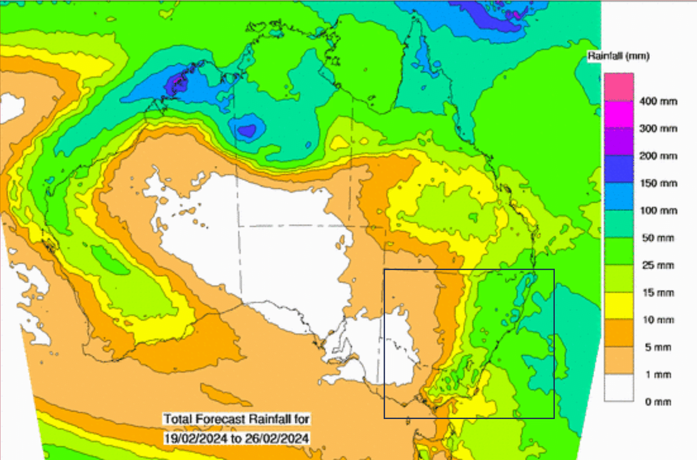
7 Days Forecast of NSW Weather:
20th February: Comparatively less thunderstorm or showers activity that mostly limited to coastal areas. Still few isolated severe thunderstorm possible.
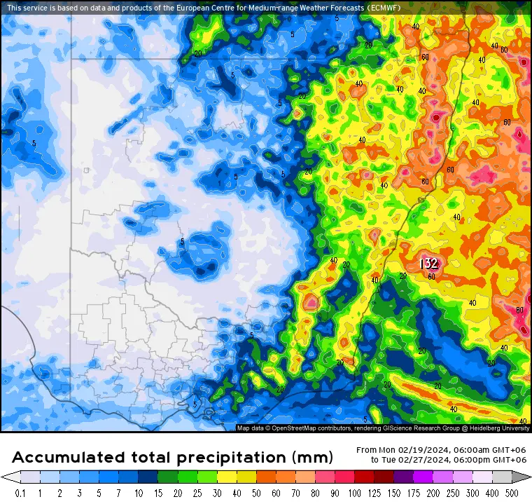
21st-23/24th February: Daily thunderstorms or showers likely over most of the mentioned region. Some severe thunderstorm possible over isolated places. Rest should have partly cloudy skies.
24/25th-27th February: Showers and thunderstorms are forecasted to ease off from most of the area. Basically allowing sunny and fair weather.
New South Wales Precipitation Forecast: Meteologix ECMWF Model
7 days Forecast of Sydney Weather:
The Sydney weather forecast from the 20th to the 27th of February 2024 indicates a continuation of daily thunderstorms or showers until the 24th of February.
There is a possibility of some severe thunderstorms around Sydney on the 20th of February. However, winds are expected to remain light throughout the week. Showers and thunderstorms are forecasted to ease off starting from the 25th of February.
Sydney weather to be mostly clear to partly cloudy from 25th to 27th February 2024. Check Sydney radar image here to track weather in live.
See Also: Cyclone Lincoln: May Re-intensify Wednesday off Kimberley Coast
See More: Mauritius Weather: Tropical Cyclone 16S to Pose a Risk of Landfall
More: Cyclone Lincoln: Severe Weather Warning for NT and Kimberley Region
Safety Advice from State Emergency Service (SES):
*Keep clear of creeks and storm drains to avoid potential hazards.
*Avoid walking, riding, or driving through floodwater to prevent accidents.
*Seek refuge in the highest available place if trapped by flash flooding, and call 000 for rescue if necessary.
*Exercise caution in fire-affected areas, as rainfall runoff may behave differently and contain debris.
*After bushfires, be aware of the increased risk of landslides due to softened ground.
*Unplug electrical appliances, avoid using the phone, and stay indoors away from windows during the storm.
*Stay vigilant, especially in monitoring conditions in areas affected by recent bushfires.
*Contact the SES (NSW and ACT) at 132 500 for emergency assistance during floods and storms.
What to do?
Residents in the affected NSW districts are urged to stay informed. Exercise caution and follow safety advice from relevant authorities to mitigate risks associated with heavy rainfall, severe thunderstorms and potential flash flooding.
Monitoring NSW weather updates and being prepared to take appropriate action are crucial during severe weather events.
Advertisements

