Typhoon Maria is heading towards north Eastern Japan
Typhoon Maria Update Time: 090900Z (09:00 UTC on August 9, 2024) | 18:00 JST on August 9, 2024
Highlight: “Maria will gradually intensify over the next 24 hours, reaching maximum sustained winds of 70 knots (130 km/h or 81 mph) before starting to weaken again”
Typhoon Maria’s Current Position and Intensity
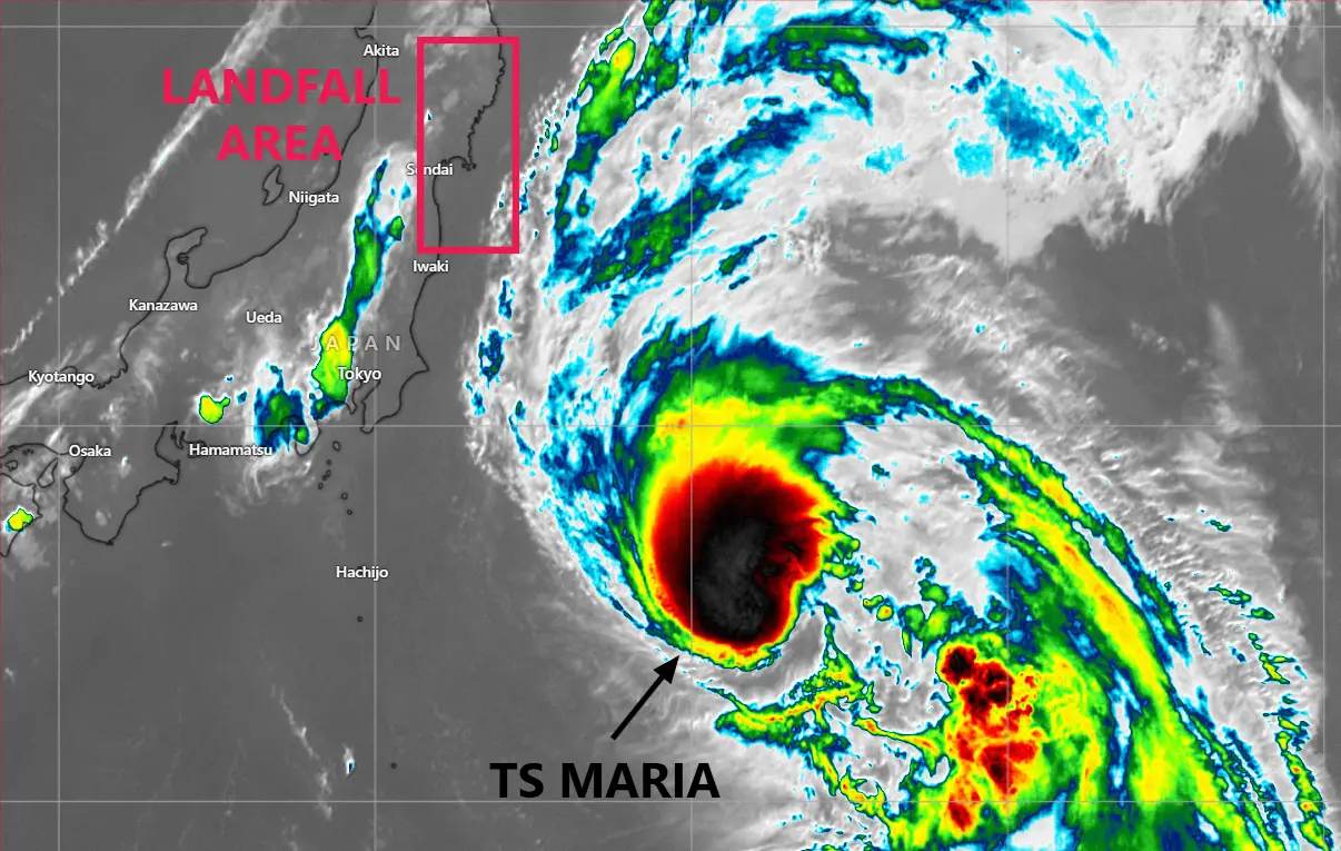
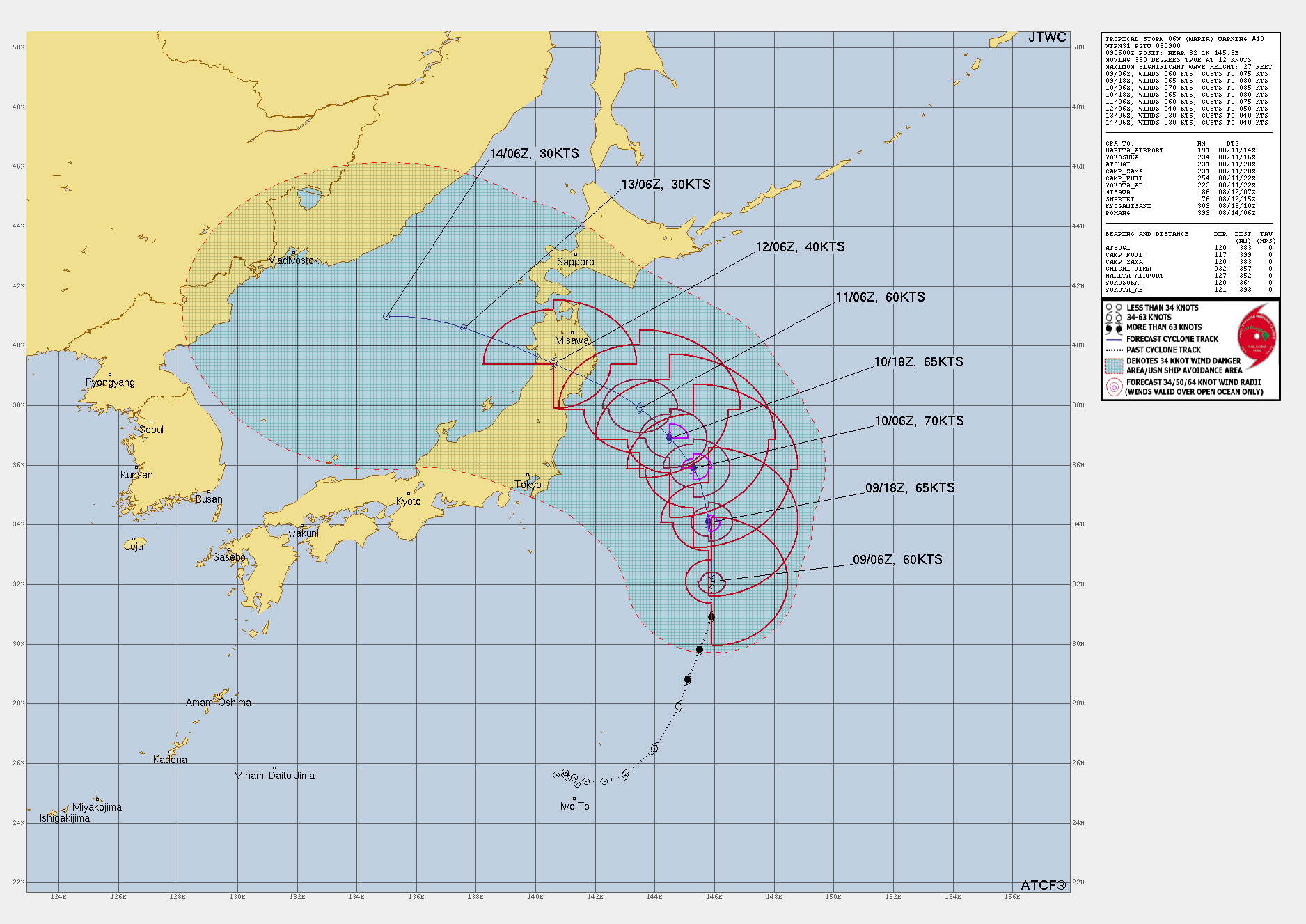
Tropical Storm Maria, previously classified as Typhoon Maria (06W), has weakened in the Northwest Pacific Ocean. As of the latest advisory from JTWC, Maria is located near 32.1°N, 145.9°E, approximately 364 nautical miles (675 kilometers) east-southeast of Yokosuka, Japan.
The storm has sustained winds of 60 knots (111 km/h or 69 mph) with gusts up to 75 knots (139 km/h or 86 mph).
Over the past six hours, Typhoon Maria has been tracking northward at 12 knots (22 km/h or 14 mph).
Satellite Analysis and Environmental Conditions for Tropical Storm Maria
Recent satellite imagery and analysis from JTWC have provided critical insights into Maria’s current structure and intensity. Animated multispectral satellite imagery (MSI) indicates that Tropical Storm Maria is positioned to the west of a subtropical ridge (STR) with medium confidence.
The storm is well-organized, with strong poleward and equatorward outflow, and is currently on a northerly track. However, the low-level circulation center (LLCC) is obscured by a central dense overcast (CDO), making it challenging to assess the exact center of the storm.
A 090723Z GMI 89GHz microwave image shows an asymmetric convective field, with the bulk of the deep convection displaced to the north of the LLCC. The accompanying 37GHz image revealed defined low-level banding features wrapping into the assessed center, which has been placed with high confidence.
The initial intensity of 60 knots has been assessed with medium confidence, based on a combination of subjective and objective aids, including Dvorak T-numbers and microwave imagery.
Current Environmental Factors Affecting Tropical Storm Maria
Tropical Storm Maria is currently in a marginally favorable environment for further development. Vertical wind shear (VWS) is between 10-15 knots, sea surface temperatures (SST) are in the range of 28-29°C, and the storm exhibits strong poleward and equatorward outflow.
However, the potential for intensification is being degraded by the presence of drier air extending from the west to the north side of the system, as indicated by ECMWF relative humidity charts.
Forecast Discussion and Track Analysis of Typhoon Maria
Tropical Storm Maria is expected to continue its northward movement before beginning to turn northwest within the next 12 hours. Track speeds are anticipated to slow as a passing trough weakens the steering gradient between 24 and 48 hours.
A developing deep-layer ridge to the north of the system, extending from the Sea of Japan, is expected to steer Maria on a more west-northwestward track towards Sendai Bay shortly after 48 hours, with landfall anticipated around 60 hours.
After making landfall, Maria is projected to continue tracking west-northwestward across Honshu and reemerge into the Sea of Japan shortly after 72 hours. The forecasted peak intensity is currently 70 knots (130 km/h or 81 mph), expected by 36 hours, as the tropical cyclone development conditions will remain marginally favorable for the next 24 hours.
However, the forecast also indicates a slow but steady weakening trend after 36 hours due to decreasing mid-level moisture and upper-level divergence. Maria is expected to start dissipating shortly after reentering the Sea of Japan.
Potential Landfall Location and date of Typhoon Maria
The landfall area for Tropical Storm Maria is expected to be Sendai Bay region in Japan. And the landfall is anticipated to occur around August 11, 2024
Model Guidance and Forecast Confidence on Maria
Numerical weather prediction model guidance has shown improving agreement regarding both track and intensity forecasts for Tropical Storm Maria. The current cross-track spread at 72 hours is 265 nautical miles, with an along-track spread of 45 nautical miles.
Both the GFS and ECMWF trackers are in agreement on a general northwesterly track. The Joint Typhoon Warning Center (JTWC) forecast closely tracks the consensus mean and the latest ECMWF tracker.
Intensity guidance also remains consistent, with most models predicting maximum intensities between 60 and 70 knots, with the exception of the HAFS model indicating an intensity above 70 knots.
The JTWC intensity estimate is placed on the higher end of the model guidance, driven by the compact structure of the system and the continuously marginally favorable development conditions.
Despite the agreement among models, forecast confidence varies. The track forecast confidence is medium for 0-72 hours and low for 72-120 hours, reflecting the inherent uncertainties in the storm’s interaction with the ridge and the potential land interaction. The intensity forecast confidence is medium for the entire 0-120 hour period.
Summary of the whole Update
Tropical Storm Maria is a well-organized system with the potential for slight intensification before landfall, but it is expected to weaken as it moves across Japan and into the Sea of Japan.
The storm’s track and intensity remain subjects of close monitoring, with current forecasts indicating a steady weakening trend after landfall. Residents and maritime interests in the affected areas should continue to stay updated on the latest advisories and warnings.
If You are in an old update, Check new updates here (Click Me)
Advertisements

