Potential Typhoon Kong-Rey Latest : Aiming Taiwan with Massive Intensification
As of the latest data from the Joint Typhoon Warning Center (JTWC), Potential Typhoon Kong-Rey, now Tropical Storm Kong-Rey (23W), is consolidating with increased wind speeds and is expected to intensify significantly. Here is the current update as of 09:00 UTC on October 28, 2024, regarding its position, intensity, and forecast track, alongside its potential impacts on Taiwan and nearby areas.
Current Position and Movement of Potential Typhoon Kong-Rey
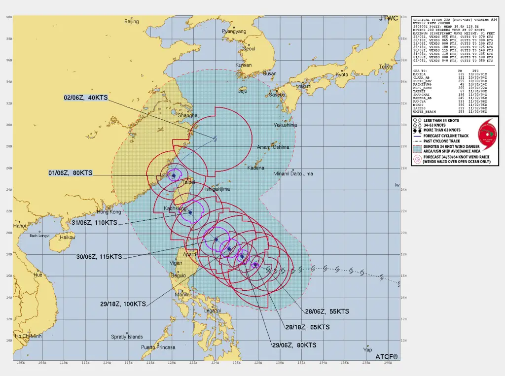
As of 06:00 UTC on October 28, Kong-Rey is positioned near 16.6°N, 128.9°E, approximately 597 nautical miles south of Kadena Air Base, Japan. The storm has been moving westward at 7 knots (13 km/h) in the past six hours and is anticipated to continue on this trajectory in the short term.
Intensity and Wind Field of Potential Typhoon Kong-Rey
Tropical Storm Kong-Rey currently has maximum sustained winds of 55 knots (102 km/h), with gusts up to 70 knots (130 km/h). Satellite observations have indicated a consolidating storm structure, with a well-defined low-level circulation center and substantial wind radii:
50-knot winds extend:
-
- 70 nm to the northeast
- 65 nm to the southeast
- 120 nm to the southwest
- 100 nm to the northwest
34-knot winds extend:
-
- 135 nm to the northeast
- 125 nm to the southeast
- 215 nm to the southwest
- 185 nm to the northwest
Forecasted Track and Intensity Changes of Potential Typhoon Kong-Rey
The JTWC’s forecast suggests that Kong-Rey will undergo rapid intensification over the next 48 hours, as it moves towards Taiwan:
12-Hour Forecast (18:00 UTC, October 28)
-
- Position: 17.1°N, 127.7°E
- Intensity: 65 knots (120 km/h), gusts up to 80 knots (148 km/h)
- Wind Radii: 64-knot winds in all quadrants reaching up to 20 nm
24-Hour Forecast (06:00 UTC, October 29)
-
- Position: 17.8°N, 126.5°E
- Intensity: 80 knots (148 km/h), gusts up to 100 knots (185 km/h)
- Wind Radii: 64-knot winds up to 40 nm northeast, 30 nm southwest
48-Hour Forecast (06:00 UTC, October 30)
-
- Position: 19.4°N, 124.1°E
- Intensity: 115 knots (213 km/h), gusts up to 140 knots (259 km/h)
72-Hour Forecast (06:00 UTC, October 31)
-
- Expected to approach southeast Taiwan, likely at Category 3 strength with winds near 110 knots (204 km/h).
Read more:
Potential Typhoon Kong-Rey (23W) to bring disaster to Taiwan
Tropical Storm Kong-Rey to Intensify over Western Pacific
How to Predict a Tropical Cyclone? Best Tips for Cyclone Prediction
Long-Range Forecast and Impacts of Potential Typhoon Kong-Rey
The storm is expected to take a northwest path approaching Taiwan, likely reaching peak intensity by October 31 before starting a northward recurve influenced by a shifting subtropical ridge and a midlatitude trough.
*//Residents in Taiwan, the Ryukyu Islands, and southern Japan should prepare for intense typhoon conditions with possible landfall near southeast Taiwan within 72 hours//*
JTWC rates the current forecast confidence as medium due to circulation complexity and potential track variance.
If You are in an old update, Check new updates here (Click Me)
Advertisements


