Tropical Cyclone Alfred Latest Forecast – March 6, 2025, 1500 UTC
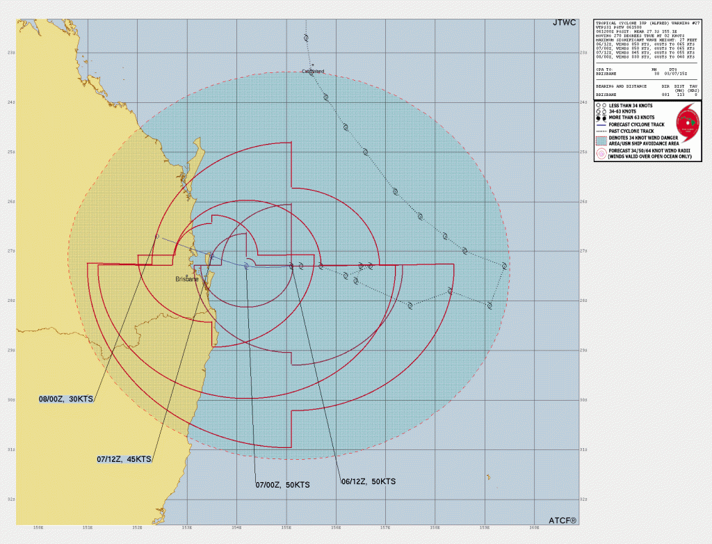
As of Tropical Cyclone Alfred Latest Forecast, Alfred(TC 18P) continues its slow approach towards the eastern coast of Australia. As of the latest update at 1500 UTC on March 6, 2025, the cyclone is located approximately 113 nautical miles (209 km) east of Brisbane, moving westward at 4 km/h.
Current Status as of Tropical Cyclone Alfred Latest Update
- Location: 27.3°S, 155.1°E
- Wind Speed: 93 km/h
- Significant Wave Height: 8.2 meters
- Sea Surface Temperature: 25-26°C
- Movement: Westward at 4 km/h
- Environmental Conditions: Unfavorable, with strong vertical wind shear and dry air entrainment
Satellite Observations and Analysis of TC Alfred near Brisbane, Australia
Recent satellite imagery shows a nearly exposed low-level circulation, with deep convection primarily in the southern quadrant of the cyclone. Environmental conditions remain unfavorable for significant intensification, with high vertical wind shear (46-56 km/h) and weak poleward outflow limiting development.
Forecast and Expected Landfall of Cyclone Alfred
Tropical Cyclone Alfred is forecast to continue on a west-southwestward path over the next 12 hours before shifting west-northwest towards Moreton Island. Landfall is expected between 24 and 36 hours north of Brisbane. The system is predicted to weaken slightly before landfall due to cooling sea surface temperatures and continued wind shear.
- Wind Speed at Landfall: Expected to be around 83 km/h
- Dissipation: The cyclone is forecast to weaken rapidly after landfall and dissipate within 72 hours.
Model Predictions and Confidence Level
Model guidance shows strong agreement on the forecast track, with all models predicting a similar path. The intensity forecast also aligns with expectations of weakening after landfall.
- Track Confidence (0-72 hrs): High
- Intensity Confidence (0-72 hrs): High
Potential Impacts on Eastern Australia
- Heavy Rainfall: Persistent rainfall is expected over coastal Queensland, leading to potential flash flooding.
- Strong Winds: Gusts exceeding 100 km/h may affect coastal areas.
- Rough Seas: High waves and storm surge could pose a threat to marine activities.
Residents in the affected areas are advised to stay updated on official weather warnings and prepare for severe weather conditions. Stay tuned for further updates as TC Alfred progresses towards the Australian coast.
If You are in an old update, Check new updates here (Click Me)
Advertisements