Potential Typhoon Kong-Rey (23W) Advisory and Forecast Update, Taiwan
The Joint Typhoon Warning Center (JTWC) has issued the latest advisory on Potential Typhoon Kong-Rey (23W), active in the Northwest Pacific. Here’s the current update on its position, intensity, and forecasted track, along with detailed wind radii and expected impacts.
Current Position and Movement of Potential Typhoon Kong-Rey
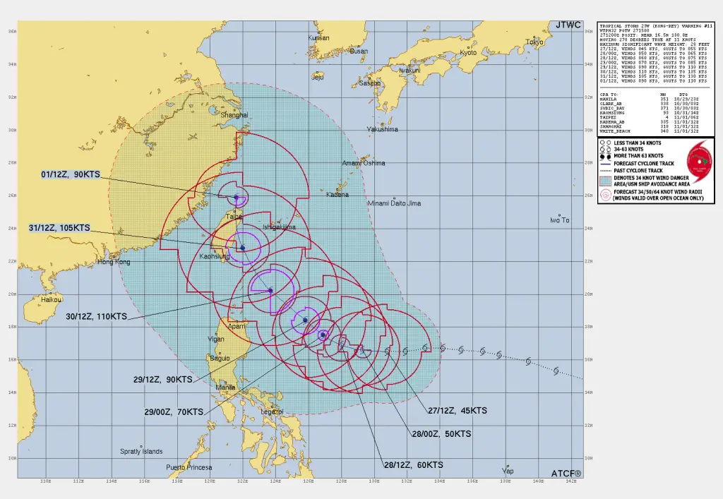
As of 12:00 UTC on October 27, 2024, Potential Typhoon Kong-Rey is located near 16.5°N and 130.8°E, approximately 623 nautical miles south-southeast of Kadena Air Base, Japan. Over the past six hours, the storm has moved westward at 11 knots (20 km/h) and is expected to continue on this path in the short term due to a subtropical ridge located to the north.
Storm Intensity and Wind Field of Potential Typhoon Kong-Rey
Kong-Rey currently has maximum sustained winds of 45 knots (83 km/h), with gusts reaching 55 knots (102 km/h). The JTWC reports a minimum central pressure of 992 mb and wave heights up to 28 feet (8.5 meters) in open waters. The wind field around Kong-Rey extends quite far, covering various quadrants with substantial intensity:
- 34-knot winds extend:
- 155 nautical miles to the northeast
- 120 nautical miles to the southeast
- 140 nautical miles to the southwest
- 175 nautical miles to the northwest
Forecasted Track and Intensity Changes of the Storm
According to the JTWC‘s forecast, Tropical Storm Kong-Rey is projected to follow this trajectory:
Westward Track for the Next 24-48 Hours: The storm is likely to continue its westward movement, guided by a subtropical ridge positioned to the north.
Gradual Intensification Over the Next 3 Days: Kong-Rey is situated in a moderately favorable environment with 29-30°C sea surface temperatures and moderate vertical wind shear (10-15 knots), with a strong equatorial outflow that will aid in gradual intensification.
Peak Intensity in 5 Days: By October 31, Kong-Rey may reach Category 3 typhoon strength, with sustained winds of up to 110 knots (205 km/h) and gusts around 130 knots (240 km/h).
Detailed Forecast and Wind Radii Analysis of Kong-Rey
12-Hour Forecast (00:00 UTC, October 28, 2024)
- Position: 16.6°N, 129.3°E
- Intensity: Max sustained winds 50 knots (93 km/h), gusts up to 65 knots (120 km/h)
- Wind Radii:
- 50-knot winds: 0 nm to the northeast, 30 nm to the southeast, 30 nm to the southwest, 20 nm to the northwest
- 34-knot winds: 130 nm to the northeast, 130 nm to the southeast, 160 nm to the southwest, 140 nm to the northwest
24-Hour Forecast (12:00 UTC, October 28, 2024)
- Position: 16.9°N, 128.0°E
- Intensity: Max sustained winds 60 knots (111 km/h), gusts up to 75 knots (139 km/h)
- Wind Radii:
- 50-knot winds: 30 nm to the northeast, 60 nm to the southeast, 60 nm to the southwest, 40 nm to the northwest
- 34-knot winds: 180 nm to the northeast, 170 nm to the southeast, 170 nm to the southwest, 140 nm to the northwest
48-Hour Forecast (12:00 UTC, October 29, 2024)
- Position: 18.4°N, 125.8°E
- Intensity: Max sustained winds 90 knots (167 km/h), gusts up to 110 knots (204 km/h)
- Wind Radii:
- 64-knot winds: 50 nm to the northeast, 50 nm to the southeast, 50 nm to the southwest, 40 nm to the northwest
- 50-knot winds: 90 nm to the northeast, 100 nm to the southeast, 90 nm to the southwest, 90 nm to the northwest
- 34-knot winds: 230 nm to the northeast, 210 nm to the southeast, 170 nm to the southwest, 270 nm to the northwest
72-Hour Forecast (12:00 UTC, October 30, 2024)
- Position: 20.2°N, 123.7°E
- Intensity: Max sustained winds 110 knots (205 km/h), gusts up to 135 knots (250 km/h)
- Wind Radii:
- 64-knot winds: 80 nm to the northeast, 80 nm to the southeast, 70 nm to the northwest
- 50-knot winds: 100 nm to the northeast, 90 nm to the southeast, 80 nm to the southwest, 80 nm to the northwest
- 34-knot winds: 230 nm to the northeast, 200 nm to the southeast, 200 nm to the southwest, 290 nm to the northwest
Read more:
Tropical Storm Kong-Rey to Intensify over Western Pacific
Tropical Storm Trami Aims Vietnam, Landfall on Sunday
How to Predict a Tropical Cyclone? Best Tips for Cyclone Prediction
Long-Range Forecast and Potential Impacts of Potential Typhoon Kong-Rey
By 96 hours (October 31, 2024), Potential Typhoon Kong-Rey is anticipated to shift to a more northward trajectory, tracking towards Taiwan, and eventually recurving eastward. This change in direction will likely be driven by an evolving subtropical ridge and an approaching midlatitude trough over southeastern China.
Extended Outlook (Post-72 Hours)
- Landfall Threats: The storm is expected to approach east of Taiwan and the Ryukyu Islands, potentially affecting regions along its path as it intensifies.
- Intensity Changes: JTWC projects that the storm may reach up to 110 knots (Category 3 equivalent) before slightly weakening as it undergoes extratropical transition near Kyushu, Japan.
Preparedness and Monitoring for the Potential Typhoon Kong-Rey
JTWC rates the current forecast confidence as medium, due to the presence of multiple circulation centers, which could affect track and intensity estimates. Residents in the Ryukyu Islands, Taiwan, and nearby areas should monitor the progress of Kong-Rey closely and prepare for potential typhoon conditions.
If You are in an old update, Check new updates here (Click Me)
Advertisements


