US Weather Outlook for December 8-10, 2024: Heavy Rain, Snow, and a Temperature Shift
Heavy Rain Targets the Deep South as of Latest US Weather Outlook
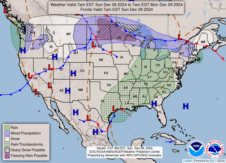
A significant weather system is poised to bring heavy rainfall across the Deep South late Sunday into Monday. A jet stream over northern Mexico will combine with a coastal front near the western Gulf Coast, leading to widespread showers and thunderstorms. Warmer, unstable Gulf air will amplify this system, heightening the risk of flash flooding.
- Areas Impacted: Lower Mississippi Valley, central Gulf Coast, and southeastern Louisiana to southern Mississippi.
- Rainfall Concerns: Marginal to Slight Risk of Excessive Rainfall from Monday to early Tuesday.
Snow and Mixed Precipitation from Great Lakes to New England as of Latest US Weather Outlook
Snowfall continues to impact areas from the Great Lakes to northern New England. A clipper system will deliver widespread snow today, transitioning to mixed precipitation as milder air moves in.
- Snowfall Totals:
- Up to 6 inches in the Adirondacks and Maine by tonight.
- 6-8 inches expected over Michigan’s Upper Peninsula and Minnesota’s Arrowhead.
- Rain Transition: Rain will follow across the Ohio Valley, northern Mid-Atlantic, and southern New England through Monday.
Unsettled Weather Hits the Pacific Northwest and Northern Plains
A cold front sweeping the Pacific Northwest will bring windy, unsettled weather this weekend. By Monday, colder Canadian air will filter southward, resulting in snow across the northern Plains and Rockies.
- Key Snow Zones:
- Northern Rockies and northern Plains.
- Black Hills could see over a foot of snow.
- Central Rockies, Front Range, and northeastern New Mexico will experience snowfall through Tuesday morning.
Dramatic Temperature Reversal Across the U.S.
Expect a striking temperature reversal as mild air surges into the central and eastern U.S., displacing recent Arctic chill. Conversely, a surge of cold air will dominate the western U.S., driven by an upper-level trough.
Key Takeaways for the Week Ahead
- Rain Risk: Watch for flash flooding in the Deep South.
- Snow and Cold: Heaviest snowfall likely in the Rockies and Black Hills.
- Temperature Shift: Warm central/eastern U.S.; cold western U.S.
Stay updated on local conditions and warnings for safe travel and outdoor plans.
If You are in an old update, Check new updates here (Click Me)
Advertisements


