Hurricane Francine Forecast : Life-Threatening Storm Approaching Louisiana
Update Time: 4:00 AM CDT (Central Daylight Time) on Wednesday, September 11, 2024.
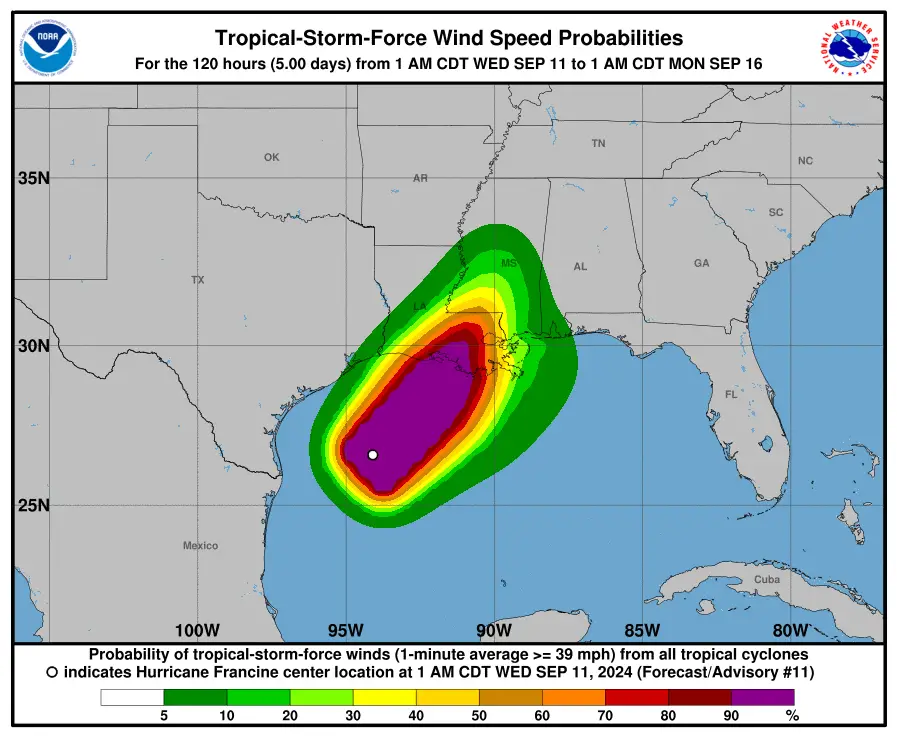
As of early Wednesday, September 11, 2024, Hurricane Francine is intensifying as it moves toward the Louisiana coast. The National Hurricane Center has issued advisories warning of life-threatening storm surge and hurricane-force winds expected to impact the region later today.
Current Location and Movement of Hurricane Francine
At 4:00 AM CDT, Hurricane Francine was located near latitude 27.0 North and longitude 93.8 West, approximately 225 miles (360 km) east-northeast of the mouth of the Rio Grande and 245 miles (395 km) southwest of Morgan City, Louisiana. The hurricane is moving northeastward at 10 mph (17 km/h) and is expected to increase speed as it approaches land. Francine is forecasted to make landfall along the Louisiana coast later this afternoon or evening.
Winds and Pressure of Hurricane Francine
Francine is currently packing maximum sustained winds of 90 mph (150 km/h), with higher gusts. Some additional strengthening is expected before landfall, after which Francine will weaken quickly as it moves inland. The storm’s minimum central pressure is measured at 977 mb (28.85 inches).
Warnings and Advisories in Effect
Storm Surge Warning
- Cameron, Louisiana to the Mississippi/Alabama border
- Vermilion Bay
- Lake Maurepas
- Lake Pontchartrain
Hurricane Warning for Hurricane Francine
- Louisiana coast from Vermilion/Cameron Line eastward to Grand Isle
Storm Surge Watch for Hurricane Francine
- Mississippi/Alabama Border to Alabama/Florida Border
- Mobile Bay
Hurricane Watch for Hurricane Francine
- Lake Maurepas and Lake Pontchartrain, including metropolitan New Orleans
Tropical Storm Warning for Hurricane Francine
- Louisiana coast east of Sabine Pass to Vermilion/Cameron Line
- East of Grand Isle, Louisiana to Alabama/Florida border
- Lake Maurepas and Lake Pontchartrain, including metropolitan New Orleans
Storm Surge and Coastal Hazards
Hurricane Francine is expected to cause significant storm surge along the Louisiana coast. Surge levels could reach 5 to 10 feet in parts of Louisiana, with the greatest threat along the immediate coastline near and east of the landfall location.
Inland areas, including Lake Pontchartrain and Lake Maurepas, could experience water levels rising 3 to 6 feet above ground level.
Rainfall and Flooding Risk
Francine is expected to bring 4 to 8 inches of rain across southeastern Louisiana, southern Mississippi, and parts of Alabama, with isolated amounts of up to 12 inches. This heavy rainfall is likely to result in significant flash flooding in urban areas and across low-lying regions.
Tornadoes and Other Hazards
There is also a risk of tornadoes across parts of southeastern Louisiana, southern Mississippi, southern Alabama, and the Florida Panhandle throughout today and into tonight. Additionally, dangerous surf and rip currents are already affecting much of the northern Gulf Coast.
Conclusion: Urgent Preparations for the Gulf Coast
Residents in the warning areas along the Louisiana coast, particularly near Morgan City and surrounding regions, should prepare for imminent impacts from Hurricane Francine. Evacuations and preparations should be completed as quickly as possible to protect life and property. Monitor official advisories from the National Hurricane Center and local emergency management officials for updates.
For Latest updates, visit Global Weather.
Advertisements